Mount Colden

August 31st, 2015

With half the High Peaks under my belt, one thing I have come to realize is the inanity in rating the difficulty of a mountain. To start, difficulty is very subjective and driven by circumstance — there’s a litany of factors which could make a trip a cinch or memorably tough. The most salient objection to the process is the multitude of paths (marked or not) leading to the top of many mountains, often of varying degrees of difficulty. Take Mount Colden, for instance.There are three common approaches to its top — from Lake Arnold, which by High Peaks standards is on the “easy” side; from Lake Colden which has the reputation of being one of the steepest trails in the ‘Daks; or up the Trap Dike, perhaps the most precarious and adventuresome undertaking of any. Given how different these three routes are, how could a single number be universally designated to represent a peak’s difficulty? If there is a mountain which speaks to the futility of such a task, Colden is it.

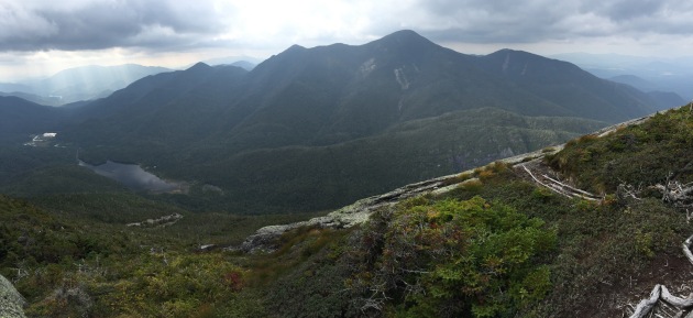
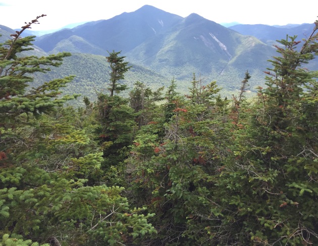
View to west from "False" Summit of Colden

View to west from “False” Summit of Colden. “Real” Summit (left) and MacIntyre Range (center) in distance.

Conventionally, Colden is done as a loop, the Lake Colden and Lake Arnold trails paired together. The former, as it is steeper, is typically chosen for the ascent, with the more genial finish to Lake Arnold. In a flourish of intrepidity (well, not quite), I took Lake Arnold out and back.

On this day, I wasn’t sure whether I would tackle Colden or finish off what I had started with Wright and bag its bigger brother, Algonquin. I vacillated until the trail split, then I veered with great ambivalence to the left, Marcy Dam-bound. This was my first time doing the trail from said split to Marcy Dam, which I could now do blindfolded. (Now there’s an event idea for the ADK club!)

two_coldens

As I arrived at Marcy Dam, Colden had its head in the clouds. I hoped the time it took me to get up there would be enough for the clouds to have had their fill and move on.

I was making good time as I came upon a sign that said Lake Arnold was only half a mile. Shortly after this point, the trail was effectively a rock ridden stream. Time passed and I remarked to myself, ‘gee this is a long half mile.’ By now, I understood, mountain miles and street miles are two different species — but I was convinced I must have gone half a mile, mountain or otherwise. Disconcertingly, I began to descend and was confident Colden was up to my right and growing farther behind me. I was in an unenviable position — continue on possibly more off course or return and, if mistaken, lose hard earned ground which I would have to redo. Obstinate minded, I chose to continue on and grew more concerned with every step. I was really in the wilderness. I tussled with the idea of doing Skylight but I had not researched it enough.

My decision to turn around was made easier when passing over a boggy section on a log, which functioned more like a see-saw than a bridge. The muddy water looked like it was ankle deep until I fell in it and was submerged up to my waist. I would later learn this was the Feldspar Bog which I surmised it was from the map. I headed on back and finally saw Lake Arnold through the trees — I hadn’t before. Moments later, I came upon the sign for the turn-off to Lake Colden. What happened was I had my head down while balancing, like a tight-roper, over some puncheon and completely missed the big sign. All and all, I had unwittingly protracted my trip 2.5 miles (give or take half a mile).

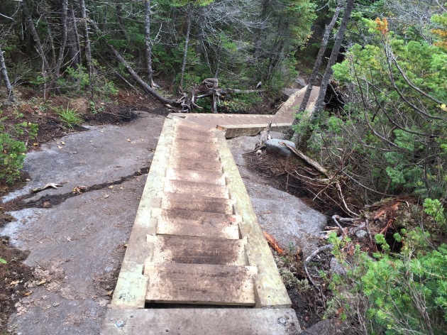
Ladders on Colden.

New ladders near summit. 

Lake Arnold wasn’t much to look at it, Miyoko calls it spooky and I can see why. Though, it must be a chic resort for mosquitos at the right time of the year. The trip up to Colden wasn’t terribly challenging, there were some brief steep parts but nothing outrageous. I came upon the “false” summit which had a view commensurate, if not better, than the “legitimate” summit. The false, the faux, the ersatz, the disingenuous summit, call it what you may, was more expansive than the real one. I descended back into the trees, over about three ladders down and up from the col, more steps-cum-ladders than the vertical variety. From what I gather, these ladders are new. Before the real summit, I had to sneak under a giant glacial erratic. It felt hazardous — what if the rock decided it was time to move and end its epoch-spanning sedentary lifestyle? Fortunately it did not, presumably it’s still there and conspicuous from the “false” summit.

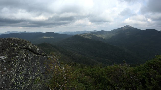
view to west from Colden

View to west from “Real Summit.” Flowed Lands and Lake Colden (below to left).


Notwithstanding the overcast conditions, I was able to see Colden’s potential. I had expected it to be good — after all, Colden owns a prime piece of real estate, smack dab in the middle of the Macs and Marcy. Colden has bald summit characteristics but it isn’t a true bald summit. The baldness gene runs in the MacIntyre family but Colden’s balding looks like it’s in the early stages. It could use some Rogaine or an alpha-reductase inhibitor to thwart its fate of baldness. (For the record I’m being facetious). It’s not a lost cause like the Macs in this regard though, for the sake of views, visitors wish it were.

View from Colden to east.

View to east: Marcy (left of center), Gray, Skylight, and Redfield. Giant way back in the distance (far left) and Great Range (to Giant’s right). 

The first view I was treated with was to the west, of the Macs, about as good as any, and downward the slide which leads to Colden’s famous Trap Dike. The Trap Dike was not visible though Avalance Lake was, as well as Lake Colden and the Flowed Lands. A gentleman, of foreign descent, peered down the slide and asked if this were a way down. I said technically it was but you ought to know what you are getting yourself into. He heeded my advice and headed back the way he had come. Even Trap Dike enthusiasts are chary of the going down part.

Once the gentleman left, I was alone on the summit. On a nicer day, I am certain this would not have been the case. The two ledges, on either side, were rent asunder by a sea of cripplebrush. On the eastern side, the triumvirate of Marcy, Skylight and Redfield dominated the view, as a mostly foreshortened Great Range wound to Giant. As Colden shows its more interesting side to the MacInytre Range, the view, to the west, of the MacInytre Range, was more interesting and dramatic than the view to the east.

view from Colden, south and east.

View from descent to Lake Arnold. South to east. Cascade and Big Slide (both left).

It can be argued no peak in the Adirondacks possesses as much character as Colden. Namely for its distinctive shape and its famed Trap Dike. Likewise, my dad thinks it’s the most distinguishable of them all based on pictures I have sent him. I hope to revisit on a nicer day sometime soon.

Prospect Mountain … third times a charm.

Prospect Mountain or, to the High Peaks and Whites crowds, the analogue of Whiteface and Washington, respectively. Well, maybe I should curtail the hyperbole; nonetheless it is yet another sacrifice of nature to man, with a five and a half mile highway girdling its way to the top. I have been to 2,034 foot summit of Prospect three times, twice have I hiked to the top (2.9 miles round trip) and once by car with my father. The first time was on foot, it was a muggy overcast day in late June in the company of two friends. The second time was up the highway with Dad, it was a variably cloudy and hazy August day. Last week, I hiked up alone with a fresh perspective, channeling my inner Verplanck Colvin purposefully forging a new route to the top, through brush, the steep terrain of Prospect’s shoulder, and over lichen covered rock. My search for a new route to the top began from the large open rock face from which the red (or only maintained) trail veers to the left, I did not stray from the red trail the first time though one of my friends was intent on it. I eventually caught up with the (defunct?) blue trail. I only knew of the red trail’s existence. The blue trail traversed wondrous umbrage and was hard to follow in the midst of fallen leaves. It eventually connected with the red trail, just before the summit.

View to the south from Prospect Mountain

View to the south from Prospect Mountain. 

On this afternoon, I come to learn Prospect actually has a nice view despite the encroachment of civilization. There isn’t a cloud to be seen, save for a ridge on the southern horizon. Though it has long passed up north, the foliage remains at peak (or barely past it) in the Lake George area. I study the contours of the High Peaks while the shuttle bus ineffectually comes and goes, whooshing to a halt, with nary a passenger getting off. Santanoni is unmistakable, given its size and southwestern position in the High Peaks; the long rounded ridge of Skylight confirms Marcy for me, the Macs must be to the left, to the right Haystack looks like a pyramid with precipitous sides, continuing to the right Basin, and Saddleback barely discernible off the shoulder of an anonymous mountain in the foreground, Gothics even less so; the nipple of Nippletop is manifest, makes sense as it is a similar vantage point to Elk Lake; the Beckhorn is hard to see, Dix looks imposing but rounded, Marcy-like, not pointy like it does up there; Giant and Rocky Peak Ridge, and the long ridge rippling towards rte. 9 (which, of course, is not visible).

[I would later consult Caltopo and use the “View From Here” feature. Lo and behold, Lower Wolf Jaw is nestled into the “valley” of Blue Ridge Mountain (which is south of the High Peaks) and Nippletop. Looking at a picture I had taken, I confirm the indistinct bump that is Lower Wolf Jaw is, in fact, visible from Prospect. Who would have thought you could see LWJ from Prospect?]

I scan the south from a ledge — the serpentine Northway fades into the expanse of land, clumpy with civilization. Supposedly one can see Albany on a clear day, which this would qualify as, yet I fail to find an intimation of it.

The trip down is more open rock than I remember. I am astounded by how wide the trails are, I’ve grown accustom to the narrower trails in the High Peaks. The wide trails aren’t necessarily an indictment of irresponsible hiking — this trail exists in the wake of a funicular railway which once transported visitors to a hotel at the top, which burned down a few times. Pieces of the railway still remain, the most substantial piece is at the top.

The five and a half mile long Prospect Veteran’s Memorial Highway was opened in 1969 and there is a $10 admission to ride. If I remember correctly, there are three turn-offs, each offering a different view of Lake George.

Giant Mountain

July 20th, 2015

While riffling through my photos one night, I came to the series of pictures I had taken from Giant. Giant was but my third peak, only my second visit to the High Peaks. Even to a fledgling 46er, its immensity was manifest. Way back when, it was dubbed “the Giant of the Valley,” and it comes of no surprise, to the east, at near sea level, virtually all 4,626 feet of it soars above. Giants stands sentinel to Keene Valley, from just about anywhere its rocky lineaments of a tempestuous past and broad rounded ridge are a familiar sight. Giant — along with Rocky Peak Ridge — appearing from afar, are first to bid welcome to visitors from the south traveling up 87.

Minimalist interpretation of Giant

What a minimalist designer’s interpretation of Giant would look like.

Looking over panoramas taken from the summit, there is now context to the view. I have since partaken in many adventures in the ranges arrayed obliquely throughout the Valley. A few of them have begun from St. Hubert’s — the Ausable Club golf course appearing as a small green patch in the midst of wilderness.

A view from the summit of Giant

A panorama from the Summit of Giant.

There are two routes up to Giant from Rte. 73 — the Roaring Brook Trail (which I took) and the Zander Scott Trail (or Ridge Trail) from Chapel Pond. The latter allegedly has the edge in views — and steepness. Gaining over 3,000 feet of elevation in merely three miles. I’ll be the first to tell you, the Roaring Brook Trail does not have a merciful gradient, either — with an elevation gain of over 3,300 feet in 3.6 miles.

The finest excursion from the Roaring Brook Trail are its namesake falls. The top of the falls provide a nice view of Noonmark and the lower Great Range. Be careful not to get too close to the edge, your decision may be terminal.

The Zander Scott Trail has benefited from misfortune — a past forest fire denuding trees and engendering views.

A view from the top of Roaring Brook Falls.

A view of the Lower Great Range from the top of Roaring Brook Falls.

Rocky Peak Ridge from Giant

Looking south towards Rocky Peak Ridge. Dix and Nippletop to the right.

Both the Roaring Brook and Zander Scott trails converge not far from the summit, the steepest portion occurring thereafter. Additionally, there are two less traveled trails to the summit of the Giant — one coming from New Russia and climbing over Rocky Peak Ridge and every mountain on its ridge. This trail is regarded as perhaps the most beautiful in all the Adirondacks but a price is to be paid for the views — it is proportionately strenuous to its beauty. The fourth, the least popular, comes in from the north. I don’t know very much about this trail.

Giant Mountain from Ausable Club

Giant dominates the view from the Ausable Club. Save this view for after the hike instead of before it. It’s the difference between fulfillment and intimidation.

Phelps in Pictures

July 31st, 2015

The bridge from South Meadow Road to the Truck Trail which leads to Marcy Dam. Phelps was a transformative hike for me — it was the first Hike Peak I ever did alone. Of the 19 peaks I’ve done since, I have done 16 alone. While I enjoy the company of others — having someone with whom to share the beauty of nature and the security component — there are virtues to hiking alone. For one, I can go at my own pace, be it fast or slow — and go whenever I want, no coordinating schedules. Hiking alone is also a firm lesson in self-reliance and has been personally strengthening.

The bridge from South Meadow Road to the Truck Trail which leads to Marcy Dam. Phelps was a transformative hike for me — it was the first Hike Peak I ever did alone. Of the 19 peaks I’ve done since, I have done 16 alone. While I enjoy the company of others — having someone with whom to share the beauty of nature, as well as the security component — there are virtues to hiking alone. For one, I can go at my own pace, be it fast or slow — and go whenever I want, no coordinating schedules. Hiking alone is also a good lesson in self-reliance and has been personally strengthening (I hope).

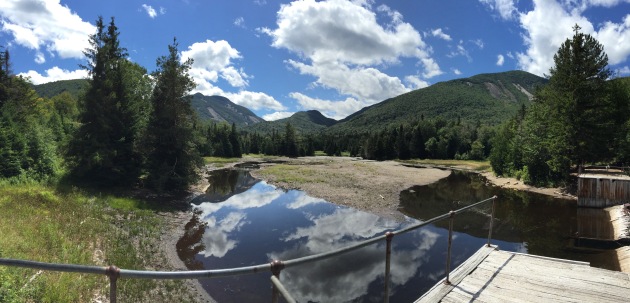
This was also my first time seeing Marcy Dam, or what remains of it. It’s as if it got through with a lengthy divorce from Irene and was left with nothing. Sadly, the process to dismantle the dam has begun.

This was also my first time seeing Marcy Dam, or what remains of it. It’s as if it just got through with a lengthy divorce from Irene and was left with nothing. Sadly, the process to dismantle the dam has begun.

The turn-off to Phelps Mountain from the Van Hoevenberg trail. To this point, the hike was, more or less, easy. The final 1.1 mile is not as forgiving, involving about 1,100’ of elevation gain.

The turn-off to Phelps Mountain from the Van Hoevenberg trail. To this point, the hike was, more or less, easy. The final 1.1 mile is not as forgiving, involving about 1,100’ of elevation gain.

Expected terrain of the final mile, exposed tree roots and boulders to vault over. More smooth rock closer to the summit.

Expected terrain of the final mile, exposed tree roots and boulders to vault over. More smooth rock closer to the summit.

A panorama from the summit of Phelps Mountain. Which begins with Big Slide to the north, on to Giant, a semi-obscured Great Range running to Marcy. Ogden Schofield Phelps, a colorful 19th-century guide, regularly led parties to the top of Marcy, or “Mercy” as he called it. It was his favorite High Peak and the mountain which bears his name offers a satisfying view of it. Colden continues on to the right and view ends with the MacIntyre Range squeezing in.

A panorama from the summit of Phelps Mountain. Which begins with Big Slide to the north, on to Giant, a semi-obscured Great Range running to Marcy. Ogden Schofield Phelps, a colorful 19th-century guide, regularly led parties to the top of Marcy, or “Mercy” as he called it. It was his favorite High Peak and the mountain which bears his name offers a satisfying view of it. Colden continues on to the right and view ends with the MacIntyre Range squeezing in.

Marcy and Colden, among others. Follow the western (right) ridge of Colden down to Avalanche Pass. See if you can espy Haystack (just about imperceptibly) peaking above Tabletop Mountain, the amorphous tree-covered lump in the foreground to the left.

Marcy and Colden, among others. Follow the western (right) ridge of Colden down to Avalanche Pass. See if you can espy Haystack (just about imperceptibly) peaking above Tabletop Mountain, the amorphous tree-covered lump in the foreground to the left.

The best view of the MacIntyre Range, most notably Algonquin and Wright Peak, are to be had on the descent — or to your back on the ascent.

The best view of the MacIntyre Range, most notably Algonquin and Wright Peak, are to be had on the descent — or to your back on the ascent.